T671-637-2042 | F671-637-2041
surveyor@guamsurveyor.com Services
Our services include: Boundary Surveys, Topographic Surveys, Construction Surveys, Subdivision/Parceling/Consolidation Surveys, Geographic Information Systems (GIS), Elevation Certificates, Hydrographic (Marine) Surveys, Monitoring/Position Survey, High-Definition Scanning, Mapping/Drafting, Consulting including expert witness, and GPA Easement. We take on any size projects from small to large, from private citizens to large firms and government agencies.
Which survey is right for you?
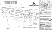
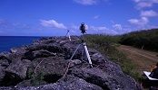
Boundary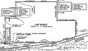 A survey to determine the boundary of a described property. It is the most common type of survey. It is requested by private owners, realtors, engineering companies, architects, construction firms, and even territorial and federal agencies. |
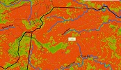
Topographic A map that indicates features on a piece of property such as elevation, relief, buildings, structures, and utilities. It is most used by engineers, architects, and construction companies. It is the foundation for the design of civil structures such as roads, buildings, and houses. |
Construction A survey to lay out features in a construction site. |
Subdivision/Parceling/
|
Geographic Information
|
Elevation
|
Hydrographic
|
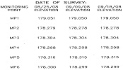
Monitoring/
|
High-Definition
|
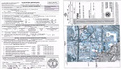
Mapping/Drafting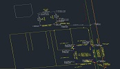 Mapping/Drafting is the use of mapping software and CAD to create maps or diagrams. This is usually requested by private owners, engineering firms, territorial and federal agencies. |
Consulting Professional consulting services are available for overall consulting in land surveying matters regarding land use and land planning. In addition, we offer expert witness or fact witness services for court testimony, depositions, and other legal matters. |
GPA Easement GPA Easement is a survey exhibit indicating the location of a power easement on a property. |